Microbursts: The Invisible Threat You Must Never Underestimate

Microbursts: The Short-Lived Storms That Can Bring Down Aircrafts
By Tushar Gupta | 6Pistons
In aviation, danger doesn’t always arrive with fanfare. Sometimes, it’s silent, sudden and over in minutes.
You’re on final, everything’s stable, the weather seems okay and then, out of nowhere, the aircraft sinks like a rock. Power in, pitch up, but it’s too late. This isn’t pilot error. It’s a microburst.
Microbursts are short-lived but violently intense downdrafts of air that slam into the ground and spread outward in all directions. They're typically associated with thunderstorms and can turn a routine approach or a takeoff into a life-threatening scenario in seconds.
In aviation, microbursts are one of the most dangerous forms of wind shear. And the worst part? You often don’t see them coming until you’re right in their grip.
Whether you’re a student pilot skimming through the Meteorology syllabus or an experienced aviator navigating monsoon-season approaches, understanding microbursts is not optional, it’s essential.
What is a Microburst?
A microburst forms when dry air mixes with rain-cooled air in a thunderstorm. The cooled, concentrated column of air descends from a Thunderstorm cloud and becomes denser and heavier, accelerating downward. Upon impact, it spreads radially outward and spreads out like a shockwave, generating sudden, severe windshear conditions.
While they’re small in scale, usually no more than 4 km wide, the intensity of the winds can rival that of a tornado. A microburst’s entire life cycle, from descent to dissipation, lasts just 5 to 15 minutes.
It’s the aviation version of a sucker punch.
There are two main types:
- Dry Microbursts – Form in hot, arid regions; little to no precipitation reaches the ground and are often invisible.
- Wet Microbursts – Accompanied by heavy rain and common during monsoon thunderstorms across India.
Both can be lethal.
Why Are Microbursts So Dangerous for Pilots?
They attack at the worst time: low altitude, high workload, final approach or initial climb.
The wind speeds inside a microburst can exceed 100 knots, nearing those of a tornado. That's enough to flip light aircraft or make a commercial jet stall during approach.
Here’s what happens if it goes unnoticed when it strikes:
- The aircraft encounters a sudden headwind, increasing lift and IAS (Indicated Airspeed).
- Pilots, sensing excess airspeed, reduce power or pitch.
- Seconds later: a downdraft, pushing the aircraft toward the ground with a sudden sink rate.
- Then, a sudden tailwind, decreasing lift and airspeed, aircraft may stall.
This deadly sequence: headwind → downdraft → tailwind can rapidly lead to a stall, loss of control, or CFIT (controlled flight into terrain).
Even experienced crews may have only seconds to react.
One of the most tragic examples is Delta Air Lines Flight 191, which crashed on approach to Dallas/Fort Worth in 1985. The cause? A microburst. It killed 137 people and triggered a complete overhaul in wind shear detection and pilot training.
Since then, onboard wind shear detection systems and Doppler radar at major airports have saved countless lives. But the danger hasn’t disappeared. Smaller airports, general aviation pilots, and rapidly developing weather still leave gaps in protection. General aviation and training aircraft are even more vulnerable, especially when performance margins are slim like extremely hot days and/or thin air (high altitudes) since loss of lift is even higher in these scenarios.
Can You Spot a Microburst?
Microbursts don’t come with flashing lights or sirens. But they do leave subtle clues:
- Localized heavy rain or virga (rain evaporating before it hits the ground)

Virga: one of the most noticeable indicators of a microburst. Image credit: Atli Arnanson
- Blowing dust or diverging rain shafts beneath storm clouds
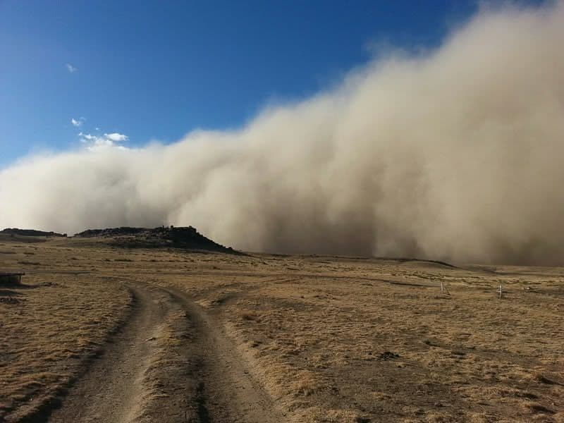
Blowing dust, another indicator of a Microburst ; Image source: NOAA
- Rapid wind shifts reported by ATC or other pilots
- Cumulonimbus clouds in active convective stages

Cumulonimbus Clouds with lightning ; Source: Turbli
- Sudden fluctuations in IAS on approach (if equipped with reactive windshear alerts)
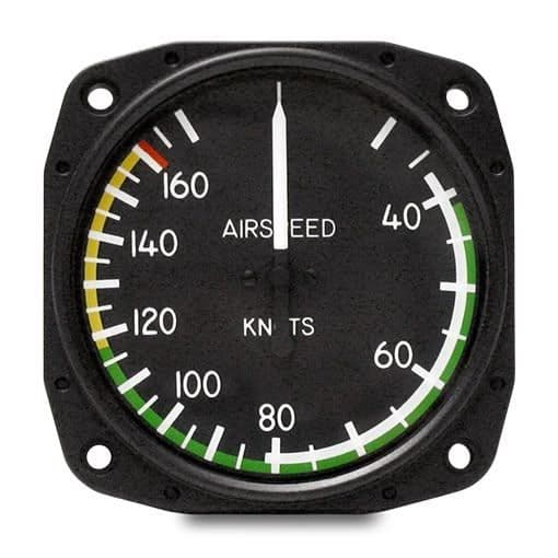
Airspeed Indicator showing IAS ; Source: Mid-Continent Instruments
In India, these are especially common between May and September, during late afternoon hours when convective activity peaks.
How Can Pilots Avoid or Survive a Microburst Encounter?
Here’s the good news: while you can’t outfly a microburst, you can avoid, recognize and escape one with the right training and discipline.
Before flight:
- Check METARs, SIGMETs and TAFs for TS, WS, or CB activity.
- Look for radar echoes on the Airborne Weather Radar ( a device used to look for weather and map the ground) and pilot reports.
- Watch for microburst potential during your WX brief, especially near active CB cells.
During approach or takeoff:
- Look out for ATC windshear alerts (from Low Level Windshear Alert System or Doppler systems).
- Go-Around Ready: Any rapid airspeed or vertical speed changes on approach? Microbursts require immediate escape action. Don’t wait for a warning to turn into a wall of wind.
- Know your aircraft’s windshear escape procedure which is generally full power, positive pitch and fly the escape profile.
- Maintain a Sterile Cockpit: On approach or takeoff in suspect weather, keep your focus. Distraction is deadly when response time is measured in seconds.
- Trust Your Instruments: Forget the illusion of stability. If your VSI, airspeed, and wind vectors start behaving oddly, believe them.
In training:
- Practice simulator recovery drills until they become muscle memory.
- Ask instructors to simulate windshear/microburst scenarios, especially in monsoon flying modules.
Final Thoughts: Short-Lived, Long Impact
Microbursts may last only minutes, but they’ve left decades of wreckage in their wake. They don’t discriminate between student pilots or airline crew, Cessna or Airbus. So next time you see isolated CBs on the radar or hear ATC mention wind shear alerts, don’t shrug it off. That pocket of descending air could be your biggest threat in the next five minutes.
The only defense is awareness, preparation, and the courage to go around when something feels off.
As pilots, our job is not just to fly the airplane but to know when not to.
✈️ For more aviation weather insights, safety tips, and real-world breakdowns, follow @6pistonsmedia on Instagram, X and LinkedIn.
We make pilot knowledge easy, honest, and impossible to ignore.
Thumbnail credits: Graf Photography
Continue Reading

FAA’s New U.S. Agent for Service Rule for International Certificate Holders
Thousands of pilots with foreign addresses risk suspension as the FAA’s new U.S. Agent rule takes effect. Here's what every FAA certificate holder abroad must know before the July 7, 2025 deadline. Missing this update could cost you your license.

How to Read a METAR Like You Actually Know What You're Doing
Most pilots can read a METAR, but using it effectively is another story. This guide cuts through the clutter to help you actually interpret METARs, SPECI, SIGMETs, and TRENDs, not just for exams, but for real flying. From spotting windshear risks to knowing when a CAVOK isn’t as perfect as it seems, this is the weather decoding skillset every serious pilot needs. Whether you're a student or in the right seat, it's time to move beyond memorization.