A Pilot's Guide to Monsoon: Must know information about India’s most dynamic season
Turbulence ahead: Cracking the code for Monsoon flying
By Tushar Gupta | 6Pistons
When the skies over India darken with dense Cumulonimbus clouds and the scent of petrichor fills the air, it marks the arrival of one of the most anticipated yet challenging seasons for aviation, the Indian Monsoon. Spanning from June through September, the monsoon isn’t just a seasonal shift; it’s an operational trial.
It varies from less than 75 days in Western Rajasthan to more than 120 days in the Southwestern regions of the country. The onset of the SW monsoon normally starts over the Bay Islands by 22 May, the Kerala coast by 01 June and covers the whole country by 08 July.
For pilots and aviation students preparing for CPL and ATPL exams as well as experienced pilots flying on the line, understanding this dynamic weather system is not just academic, it’s critical. Let's dive into the details and find out exactly how the season takes over the country.
The Science Behind the Monsoon
Multiple factors shape India's monsoon climate:

Image credits: Civil Daily
- Differential Heating: The Indian subcontinent heats faster than the surrounding oceans, owing to close proximity to the Equator and the specific heat of water being greater than land, creating a low-pressure zone over the landmass, specifically over Balochistan (994 hPa).
- Shift of the ITCZ (Intertropical Convergence Zone): ITCZ is an area of Low Pressure where the North and South Trade Winds meet. It moves according to the position of the Sun, i.e., northward during summer. In July, the ITCZ is north of the Equator guiding monsoonal winds over the subcontinent.
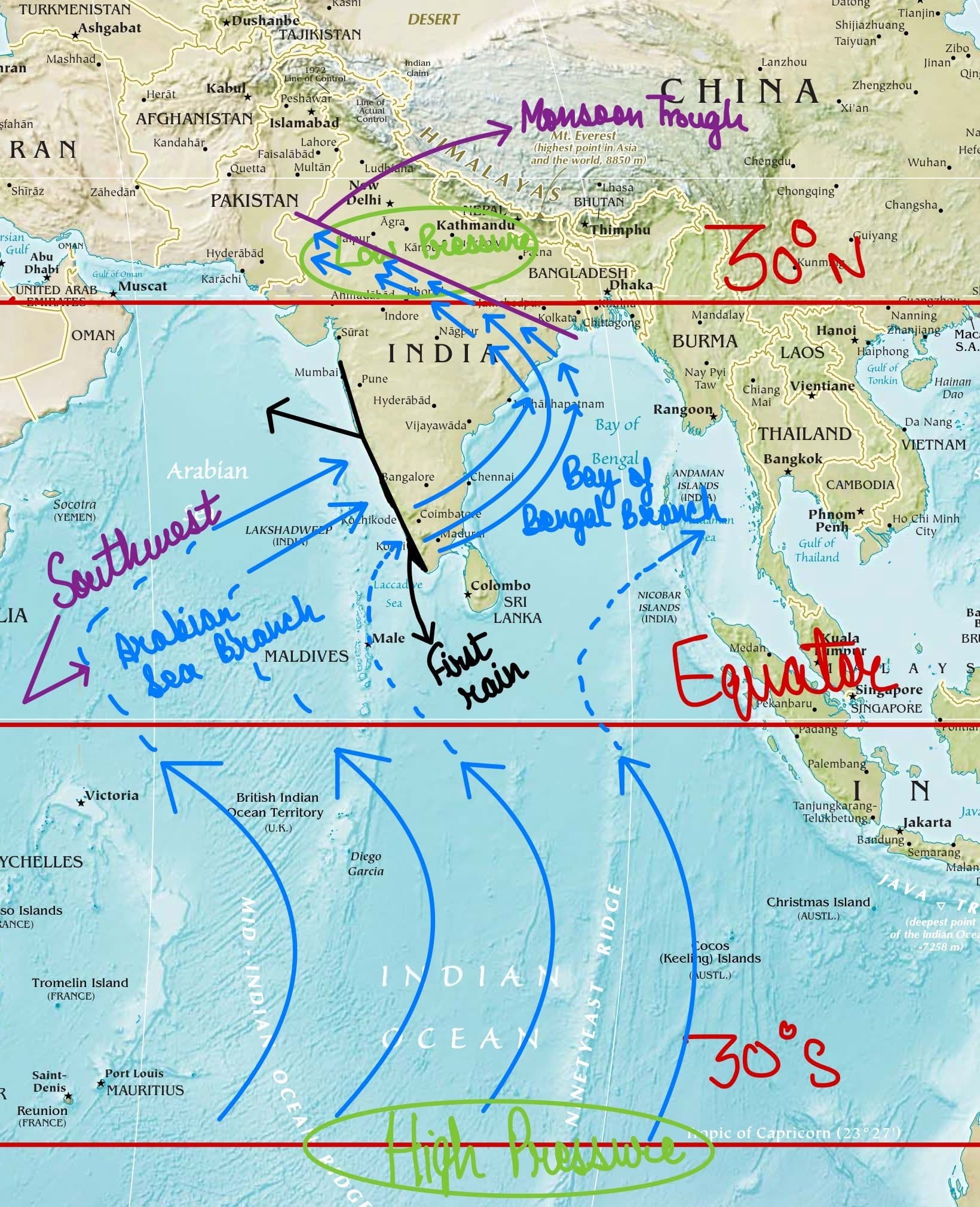
- Southwest Monsoon Winds: Moist air from the High Pressure belt in the Indian Ocean is drawn toward the low-pressure region over India. This air, originating in the Southern Hemisphere, after crossing the Equator, bends towards India due to the Coriolis force pushing the winds to the right in the Northern Hemisphere as a result of the rotation of the Earth.
- These winds are called Trade Winds, flowing from 30° N and 30° S latitudes (Only winds from the South are being discussed here). On the way, they pick up moisture while travelling over the vast Indian Ocean and strike the Indian Subcontinent from the Southwest, hence taking up the name "Southwest Monsoon".

Image credits: Research Gate
- Monsoon Trough: Monsoon Trough is an elongated low-pressure area which extends from heat Low (Low Pressure area) over Pakistan to Head Bay of Bengal. This is a semi-permanent feature of the monsoon circulation. Its Normal position is over the Gangetic plains with its Axis extending from Sriganganagar in Rajasthan to the Head Bay of Bengal. This results in active/vigorous monsoon over major parts of India. In contrast, the northward migration of this trough leads to the Break monsoon conditions over a major part of India, increasing the Pressure and heavy rains along the foothills of the Himalayas, NE India and sometimes floods in the Brahmaputra river. The MT slopes southwards with height. The position of the AMT (Axis of the Monsoon Trough) decides the position of the rainfall.
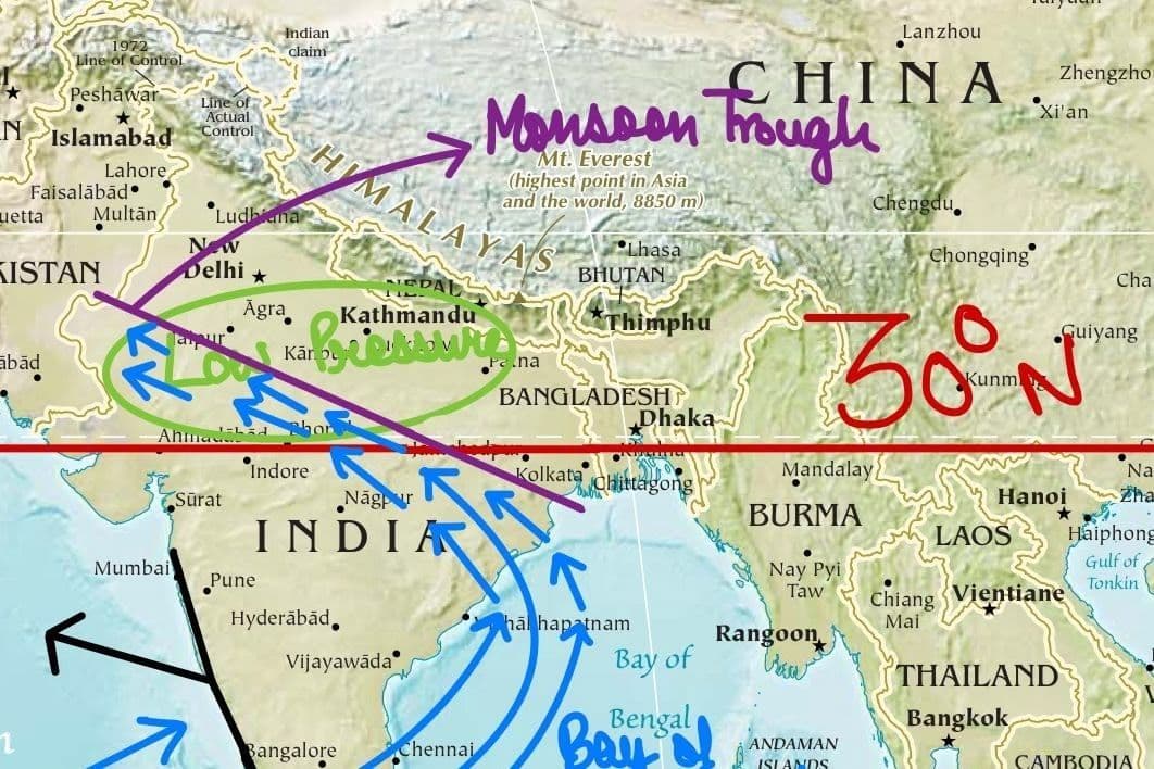
Position of the Monsoon Trough and the Low Pressure region bringing in the SW Monsoon into India.
- Western Disturbances & Easterly Waves: These influence regional variations, often triggering storms in northern and eastern India. However, WDs occur much less during this time as compared to the Post-Monsoon season when their frequency is 5-7 times a month.
- Tropical Easterly Jetstream: The TEJ is present during this season over India. It blows at an average height of 45,000 ft with a speed of 60-100 knots in an Easterly direction ( East to West). It strengthens the SW Monsoon. Above a height of 6 KM, its direction is Easterly, strengthening with height and Below 6 KM, its direction is South-Easterly over North India and West-Southwesterly over South India.
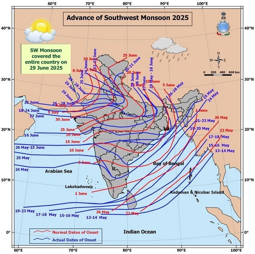
Advance of the SW Monsoon 2025; Source: India Meteorological Department
Hazards of Monsoon Flying
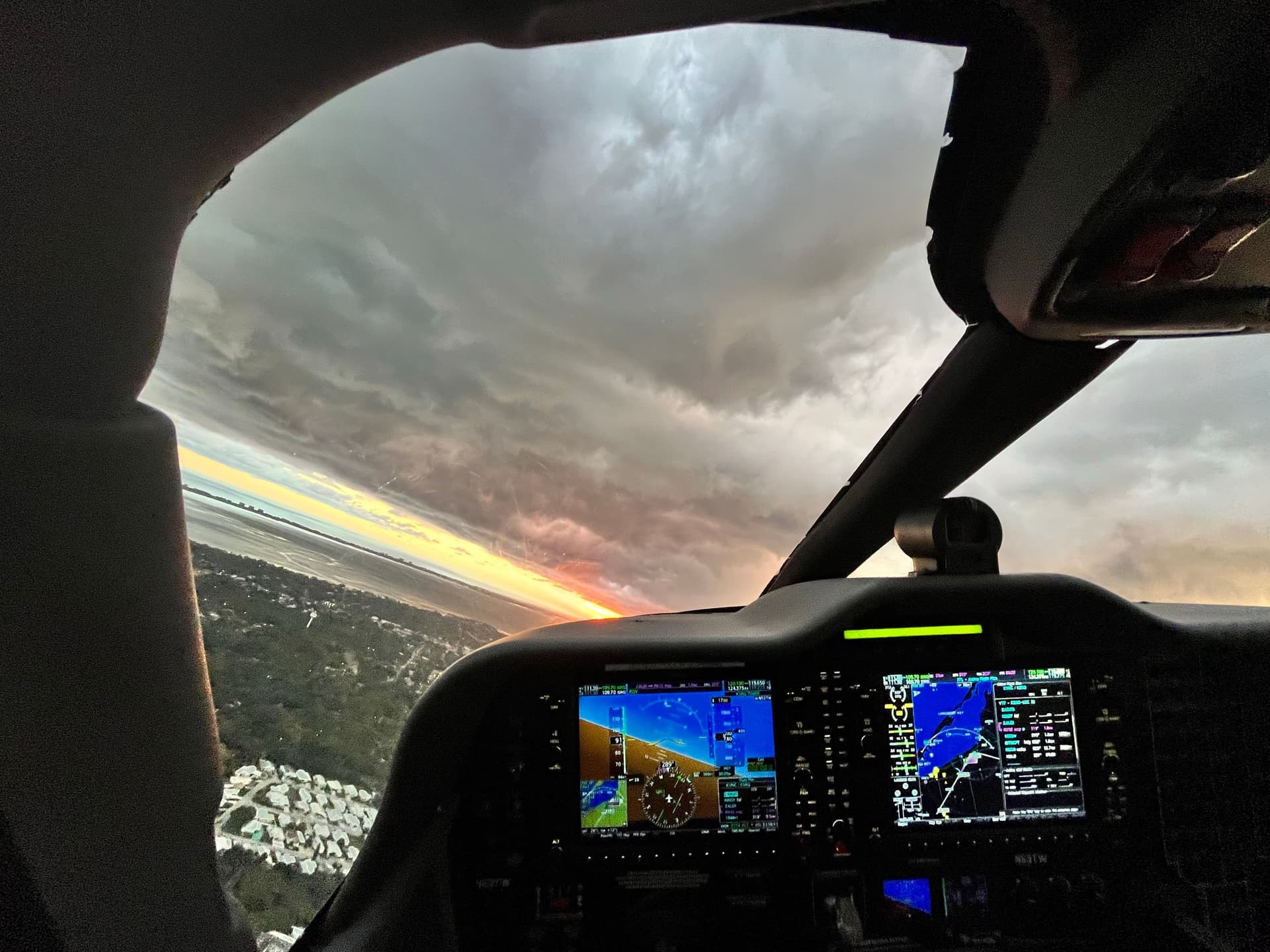
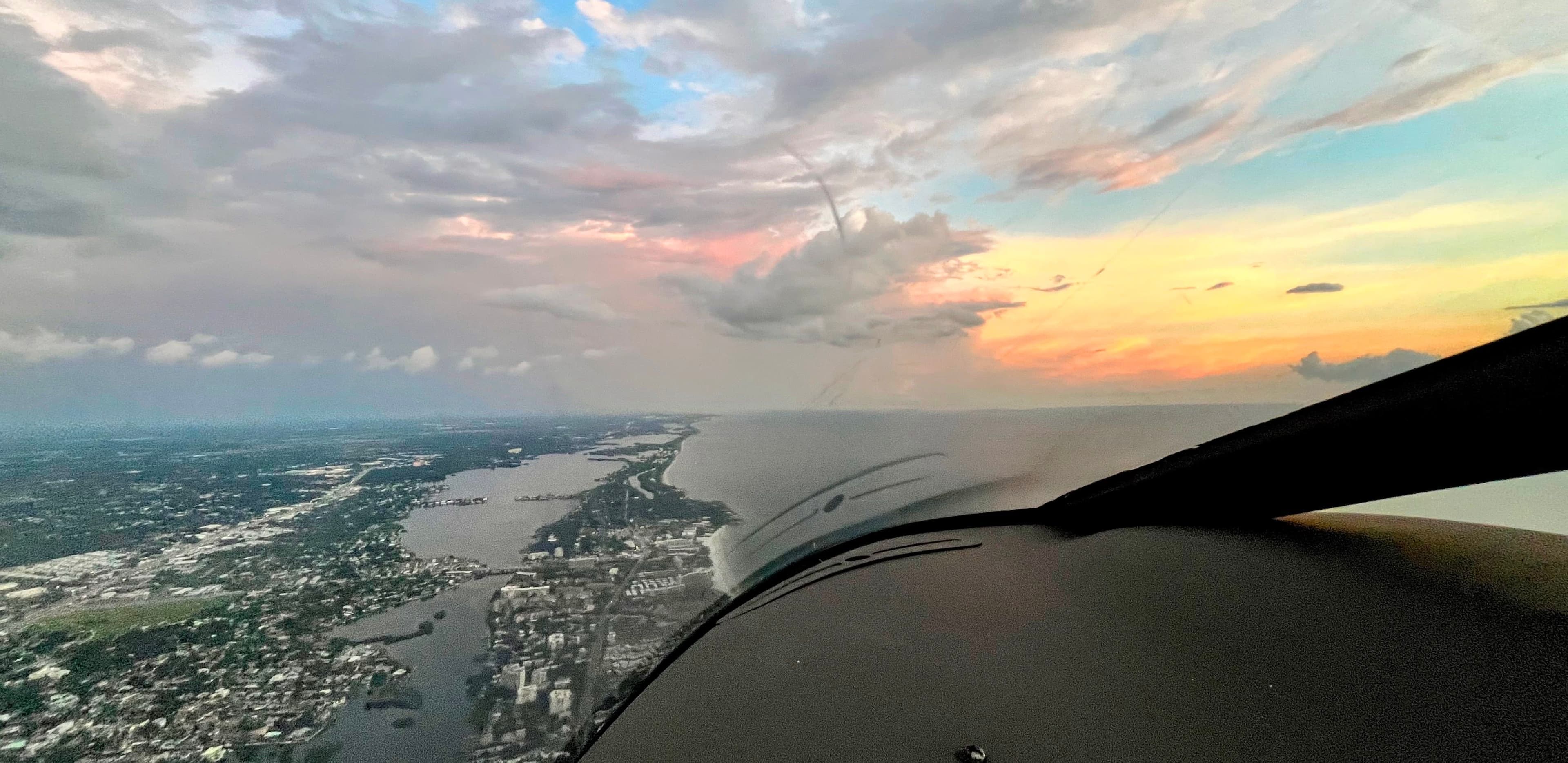
OVC during Heavy Monsoon rain; ©: Tushar Gupta
From an operational perspective, monsoon season is synonymous with unpredictability and rapidly evolving hazards:
- Cumulonimbus Clouds (CBs): These towering giants can rise to the tropopause, often triggering lightning, hail, turbulence, and microbursts. These clouds dominate METAR/TAF reports during this period.
- Heavy Precipitation: Sudden, intense rain showers lead to low visibility and slippery runways. Wet runways also increase hydroplaning risk.
- Low Cloud Bases: Can drop as low as 300 to 500 feet, making VFR flight impractical in many sectors and increasing go-around rates.
- Wind Shear & Gust Fronts: Caused by downdrafts and squall lines associated with thunderstorms, they pose a threat during takeoff and landing.
- Frequent Diversions: Poor visibility, flooded runways, and traffic congestion often lead to holding and diversions, especially in metro airports.
Stay current with real-time weather updates by bookmarking the IMD’s Civil Aviation Services page, a vital resource during India’s monsoon season.
Monsoon Season and DGCA Exam Readiness
Monsoon climatology is a core part of the CPL and ATPL syllabi. Concepts frequently tested include:
- Structure and movement of the ITCZ
- Characteristics of Southwest and Northeast Monsoon
- Types of clouds associated with monsoon
- Impact of orography (e.g., Western Ghats triggering heavy rainfall on the windward side)
- METAR/TAF interpretation during convective activity
- SIGMETs, wind shear warnings, and NOTAM relevance during monsoon
Exam Tip: Questions often revolve around how these systems influence aviation operations, especially in regions like Delhi, Mumbai, Kolkata, Chennai, and Guwahati.
For a deeper understanding, pilots can refer to the official DGCA Meteorology Syllabus PDF, which aligns with current DGCA CPL/ATPL exam standards and IMD’s live METAR/TAF data portal for hands-on study.
Pilot Procedures and Operational Adjustments
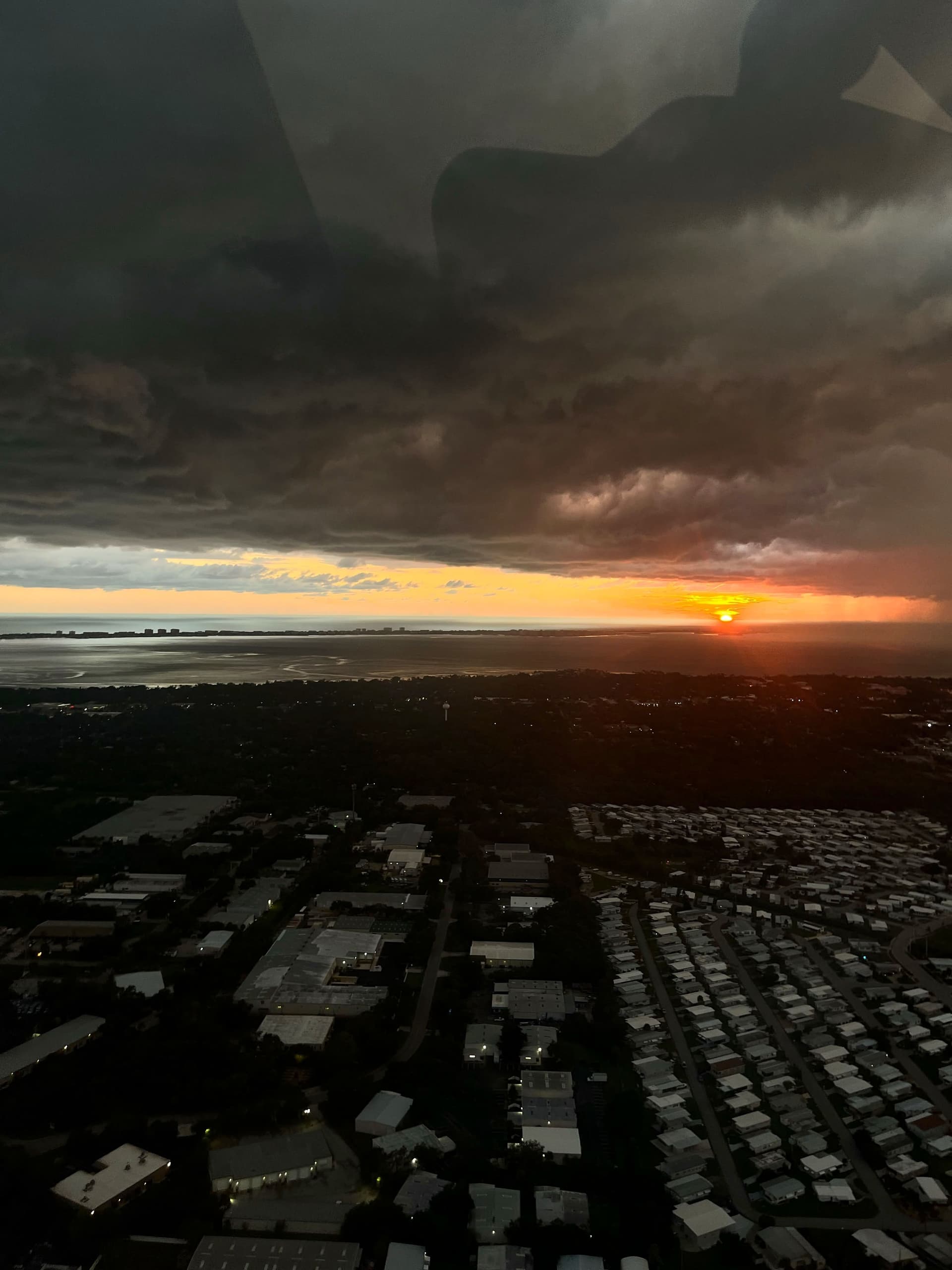
Low cloud bases with a Thunderstorm passing over West Florida; ©: Tushar Gupta
To safely navigate monsoon skies, flight crews must adapt with precision:
- Enhanced Pre-Flight Briefings: Emphasis on weather radar interpretation, alternates, and en-route diversions.
- Extra Fuel Uplift: Account for holding patterns and expected rerouting.
- Route Flexibility: Storm cells may necessitate airborne re-clearances and/or diversions.
- Increased Separation: ATC often imposes greater longitudinal and vertical separation due to traffic bottlenecks.
- Runway Selection: Favor runways with grooved surfaces and efficient drainage along with Navigational Aids to account for reduced visibility operations.
To reinforce flight planning, check out the IMD’s downloadable Aviation Meteorology manual by CAMD, which covers practical MET chart interpretation.
Region-Specific Monsoon Behaviors
- Western Coast (Mumbai, Goa): Orographic rainfall is intense due to the Western Ghats. Heavy Rainfall occurs on the Windward side.
- Northeast (Guwahati, Kolkata): Experiences thunderstorms from easterly waves.
- Northern Plains (Delhi): Late onset with heavy showers and sudden visibility drops.
- Southern Peninsula (Chennai): Gets bulk of rain from Northeast Monsoon in October-November, post-SW Monsoon withdrawal. Tamil Nadu is in the Rain Shadow area during the Southwest Monsoon.
Final Approach
Flying during the Indian monsoon is both a challenge and an opportunity. It demands strong theoretical grounding, situational awareness, and operational adaptability. For aviation students, mastering monsoon climatology isn’t just about clearing exams, it’s about earning your wings in one of the most climatically diverse airspaces in the world.
Stay sharp, stay informed, and respect the monsoon.
Let us know about your favourite season and if you're someone who prefers going out in the rain or sit at home and have a cup of tea while reeling in the comfort that Monsoon brings! Tag us @6pistonsmedia on all your favourite social media platforms.
All the photos above are property of Tushar Gupta and any reproduction or repost is strictly prohibited.
Continue Reading

DGCA Takes Over RTR Exam: A New Dawn for Aspiring Pilots
For years, RTR(A) was every pilot’s nightmare, confusing, corrupt, and unpredictable. But from December 2025, DGCA takes over, promising a cleaner, fairer exam. Why was it so dreaded? What’s changing? And what does it mean for future pilots? Here's the short version of a long-overdue fix.

SpiceJet Gets First Set of Overhauled Engines from StandardAero, Boosts Fleet Revival Plans
SpiceJet kickstarts fleet revival with two overhauled engines from StandardAero, aiming to return grounded aircraft to service through a structured engine maintenance plan.